|
| *****SWAAG_ID***** | 341 |
| Date Entered | 21/11/2011 |
| Updated on | 22/11/2011 |
| Recorded by | Tim Laurie |
| Category | Tree Site Record |
| Record Type | Botanical HER |
| Site Access | Private |
| Location | How Edge Scars. Uppermost, north facing cliff on West Bank. |
| Civil Parish | Muker |
| Brit. National Grid | NY 8660 0257 |
| Altitude | 390m |
| Record Name | MUK122. Whitsundale. How Edge Scars. West Bank, aspens on uppermost north facing Cliff. |
| Record Description | Sheer cliff well vegetated with stunted aspens |
| Geographical area | Upper Swaledale |
| Species | Aspen, stone bramble. |
| Additional Notes | The small stunted aspens on this cliff are not easily seen. Stone bramble also present. Generally acidic vegetation, but not yet recorded. |
| Image 1 ID | 1333 Click image to enlarge |
| Image 1 Description | How Edge Scars. Uppermost West Bank north facing cliff with aspen and stone bramble. | 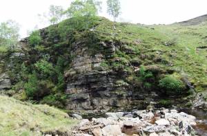 |
| Image 2 ID | 1334 Click image to enlarge |
| Image 2 Description | How Edge Scars. Uppermost West Bank north facing cliff with aspen and stone bramble. | 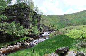 |

